# Improve PostalCode subdivision data import
**URL:** https://discuss.tryton.org/t/improve-postalcode-subdivision-data-import/6226
**Category:** Ideas
**Created:** [June 3, 2023, 7:49am UTC](https://discuss.tryton.org/t/improve-postalcode-subdivision-data-import/6226 "2023-06-03T07:49:40Z")
**Posts on this page:** 4
**Page:** 1
### Author:  [@lars\_wuerfel](https://discuss.tryton.org/u/lars_wuerfel)
#### Post date: [June 3, 2023, 7:49am UTC](https://discuss.tryton.org/t/improve-postalcode-subdivision-data-import/6226/1 "2023-06-03T07:49:40Z")
When writing a Proteus script to revise the subdivisions of a huge Party address pool,
I saw that there are countries that do not have a subdivision for all postal codes in the PostalCode module (for example Netherlands and Austria), and I found that France has two subdivisions per postal code, one of which is false for every postal code.
As far as I understand - please correct me if I’m wrong - the Country data is from [Python pycountry](https://pypi.org/project/pycountry/), and the postal code data comes from [geonames.org](http://geonames.org) .
The problem that I found is that pycountry
- uses [ISO 3166-2](https://www.iso.org/obp/ui/#iso:pub:PUB500001:en) code to identify a subdivision
whereas the export file from [geonames.org](http://geonames.org)
- in some files uses ISO codes to identify subdivisions (for example in DE.txt)
- but in other files uses [FIPS](https://en.wikipedia.org/wiki/List_of_FIPS_region_codes) region codes to identify subdivisions (for example in NL.txt and AT.txt)
Example: The Netherlands, subdivision “Flevoland”
ISO 3166-2 code (from pycountry): NL-FL
FIPS code (from [geonames.org](http://geonames.org)): NL-16
Example: Austria, subdivision “Kärnten”
ISO 3166-2 code (from pycountry): AT-2
FIPS code (from [geonames.org](http://geonames.org)): AT-02
As a result, no subdivision is available in Tryton for all postal codes in NL and AT.
To improve the situation I would
(1) analyze for which of the 96 available postal code files this problem exists
(2) give the trytond\_import\_postal\_codes script a “translation table” from FIPS to ISO codes for the affected postal code files.
I would like to contribute and work on this topic, but I may not see the big picture at the moment.
If I am on the wrong track, or the effort will forseeable fail, please tell me.
Other thoughts on how to get the subdivisions right in Tryton?
---
### Author:  [@ced](https://discuss.tryton.org/u/ced)
#### Post date: [June 3, 2023, 8:11am UTC](https://discuss.tryton.org/t/improve-postalcode-subdivision-data-import/6226/2 "2023-06-03T08:11:15Z")
> [@lars\_wuerfel](#):
>
> I found that France has two subdivisions per postal code, one of which is false for every postal code
Why is it false?
> [@lars\_wuerfel](#):
>
> but in other files uses [FIPS](https://en.wikipedia.org/wiki/List_of_FIPS_region_codes) region codes to identify subdivisions (for example in NL.txt and AT.txt)
Since September 2 2008, FIPS is deprecated.
> [@lars\_wuerfel](#):
>
> Other thoughts on how to get the subdivisions right in Tryton?
I think we should try to convince GeoNames to use ISO 3166-2 for all the files. Because we will not be able to maintain a compatibility table between FIPS and ISO.
---
### Author:  [@lars\_wuerfel](https://discuss.tryton.org/u/lars_wuerfel)
#### Post date: [June 3, 2023, 9:27am UTC](https://discuss.tryton.org/t/improve-postalcode-subdivision-data-import/6226/3 "2023-06-03T09:27:52Z")
> [@ced](#):
>
> > [@lars\_wuerfel](#):
> >
> > I found that France has two subdivisions per postal code, one of which is false for every postal code
>
> Why is it false?
For example I pick the french town “Dôle”. It is situated in the département “Jura” (ISO: FR-39) which lies in the region “Bourgogne-Franche-Comté” (ISO: FR-BFC).
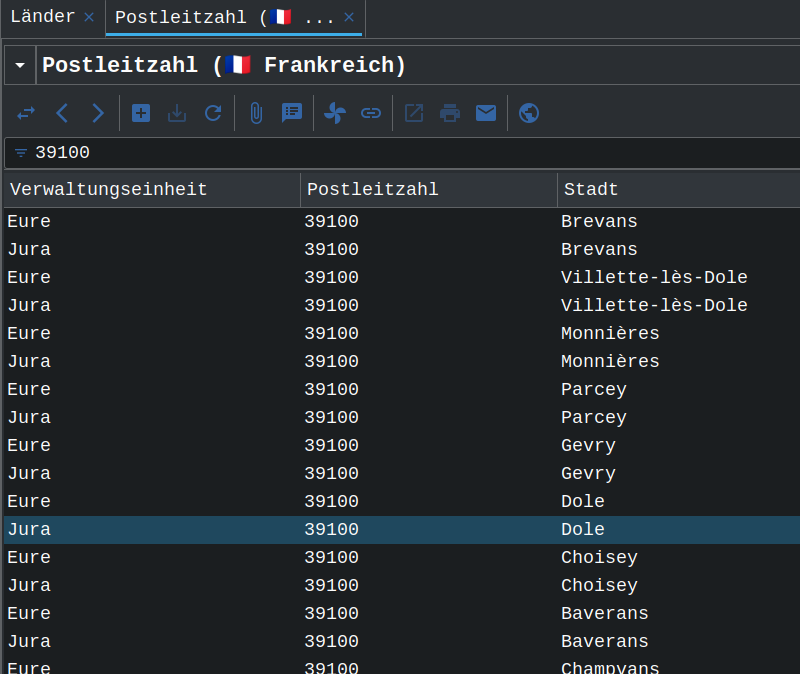
(Screenshot taken from Tryton 6.9, same in 6.8)
According to Tryton, Dôle is at the same time in both départements “Jura” (Bourgogne-Franche-Comté) and “Eure” (Normandie). This is false.
I think we can see the cause for this error [here](https://www.geonames.org/FR/administrative-division-france.html). The row “GN” is taken as identifier (here: 27), which is mapped to “FR-27”, which is the ISO code for département “Eure”.
---
### Author:  [@lars\_wuerfel](https://discuss.tryton.org/u/lars_wuerfel)
#### Post date: [June 3, 2023, 9:29am UTC](https://discuss.tryton.org/t/improve-postalcode-subdivision-data-import/6226/4 "2023-06-03T09:29:25Z")
> [@ced](#):
>
> I think we should try to convince GeoNames to use ISO 3166-2 for all the files. Because we will not be able to maintain a compatibility table between FIPS and ISO.
Ok, I will contact them and aks if it is possible. I will report here.